Gå til hovedinnhold

Reefmaster med oppdatering

Reefmaster (RM) har nettopp sluppet den betaen jeg har jobbet med de siste månedene, og dette er virkelig imponerende for en kart-nerd. Det er mange nyheter i versjon 1.6, men jeg skal gjengi noen av de:

- 64-bit versjon. Frem til nå har RM kun vært tilgjengelig som 32-bit, men etter oppgraderingen blir den automatisk 64-bit så lenge din PC støtter dette. Hvis PCen din er for gammel for 64-bit, vil RM fortsatt være 32-bit. Poenget er å få en raskere programvare, som også kan generere større kartområder. Med 64-bit kan jeg faktisk kjøre hele Tyrifjorden i en omgang, selv om det presser kapasiteten på min laptop helt til ytterpunktet.

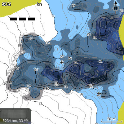
- Bunnkomposisjon. Man kan kjøpe en tilleggsmodul som gjør at man kan lage kart som viser forskjell på myk og hard bunn slik som i Insight Genesis. (Men RM har fortsatt ikke noen løsning for å vise vegetasjonsbelter slik IG har.)

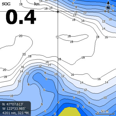
- Isobater. Dette er en annen måte å vise dybder på enn det tradisjonelle vectorformatet, og gir mye "penere" kart og som har store muligheter for tilpasninger. Ikke minst ser det veldig bra ut hvis kartet brukes i Google Earth eller på eldre Lowrance-enheter.

- Beregning av volum. Som for bunnkomposisjon er også dette en tilleggsmodul. Den bør appellere til alle som forvalter et vann, siden den beregner totalt vannvolum, vannvolum innenfor gitte dybder, volum på myk bunn/ hard bunn og andre ting som kan være greit for kultivering av vann og vassdrag.

Merk at oppdateringen ikke går automatisk, brukeren må selv sette den i gang. For å bruke bunnkomposisjonsmodulen eller 64-bit fult ut, må dine workspaces genereres på nytt. Men det er det verdt! 

Neste oppgradering er ventet til sommeren, så jeg venter i spenning på neste beta-versjon som skal støtte Lowrance og Humminbirds SideScan/ SideImaging, altså høyfrekvent ekkolodd som ser til siden.

Reefmasters egen oppdateringsinformasjon:


Update now to ReefMaster version 1.6 and check out our brand new bottom composition module!


* Bottom-composition add-on module

bottom composition of a patch of reef, shown in 3D
  • Create overlays for your map projects showing changes in the nature of the sea or lake bed.
  • Support for layers including roughness, hardness and peak signal return.
  • Export bottom-composition layers in a range of file formats, including Navico AT5, Google Earth KML and ESRI Shapefile.
  • Switch bottom-composition layers on or off in Navico™ units using the chart categories feature.
  • Select just the regions you want for display and export.
Bottom-composition is an add-on module, priced at US$49. To access the new module, you'll need a ReefMaster PRO license and to be running the latest v1.6 version.


* ReefMaster Version 1.6

Version 1.6 of ReefMaster has been released with a host of new features and improvements.
ReefMaster 1.6 is a free upgrade for all existing users. Upgrading takes just a couple of minutes, but is not automatic. Please visit this page for details on how to upgrade ReefMaster.

* Vector depth areas


vector depth areas in a map project

A powerful new feature in ReefMaster v1.6 is the addition of vector depth areas, known as isobaths.
Isobaths open up a host of possibilities, including full colour maps for older Navico™ units such as the Elite, LMS and LMX, and stunning KML vector maps for Google Earth (including on mobile devices). Isobaths can also be exported as ESRI Shapefiles for use in further GIS applications, includingcgpsmapper, which can be used to compile maps for Garmin devices.


Vector map on Lowrance HDS5, exported directly from ReefMaster


KML vector map on an Android smart-phone, exported directly from ReefMaster
 

WYSIWYG editing for AT5 maps


bottom-composition layer shown in an editable ReefMaster User Map

Vector maps allow a huge advance in map editing options within ReefMaster. User Maps now offer What You See Is What You Get (WYSIWYG) editing for Navico™ AT5 maps. Easily edit depth colours in any way you want; for example, highlight all areas within a certain depth-range with just a few clicks of the mouse. Add tracks to maps and style them as you would like them to appear on your GPS units, or draw or import paths or polygons to highlight areas of interest.


* Automatic AT5 map generation by integrating with the Navico™ Insight Map Creator

AT5 is a map format that displays on Navico GPS devices including Lowrance and Simrad. AT5 maps are created by running map data through a free Navico tool called the Insight Map Creator.
ReefMaster can now run the Insight Map Creator automatically, taking the pain out of generating AT5 maps. Vector and raster layers can be generated directly to a memory card; simply click the export option in ReefMaster, wait for the map to generate and then insert the memory card into your Navico unit.


Map directly exported by ReefMaster and shown on a Lowrance HDS5


* ESRI Grid export

Export the generated map grid in the ASCII ESRI Grid format, for use in further GIS applications.
 

* 64 Bit native deployment

ReefMaster now runs as a 64 bit application on 64 bit operating systems, which, memory permitting, allows even bigger maps to be created. We have beta testers creating maps over 15km square with a 1m grid resolution!
 

* Volumes and Areas Module

The Volumes and Areas add-on module provides area and depth calculations for map projects. Calculate the volume of water or sediment, over the whole map, or for configurable depth-bands, with configurable reference depth for sediment volume calculations.
Volumes and Areas is an add-on module, priced at US$49. To access the new module, you'll need a ReefMaster PRO license and to be running the latest v1.6 version.
 

How to update to version 1.6 of ReefMaster

Upgrading to version 1.6 is free for all existing users, but not automatic.
The process only takes a couple of minutes, and details can be found on this page.


Kommentarer

Populære innlegg

The perfect settings for Lowrance? A guide on how to set up your 2D-sonar part I.

Perhaps the most repeated question in Facebookgroups and forums regarding marine electronics: "What are the best settings?" The bad news is that there is no uniform answer to that. The good news is that you can adjust settings according to conditions if you have a little knowledge as to what settings you should tweak and why. Here is part 1 of our guide to get the most out of your unit in regards to settings.

What is the difference between HDS Carbon and HDS Live?

Here we go again, a new generation of the Lowrance HDS. And with that Facebook and the different forums are flooded with questions referring to the difference between the new and the old. So what is the difference between Lowrance HDS Live and HDS Carbon?

Lowrance Elite Ti2 versus Elite FS

  When Lowrance launches a new mid-range unit, it is a big deal. Forums and Facebookgroups light up with questions on the new stuff, differences towards the old stuff and questions on compatibility. As usual, we in Team Colibri will try our best to sort that out, both on a technical level and with a more practical in-your-boat approach.

What is the difference between Lowrance HDS Live and Elite Ti2?

Lowrance as a brand of marine electronis is well known to all anglers, but the differences within their range of different models seem to cause quite a few questions out there. Here we will try to outline the difference between Lowrance HDS Live (top end) and Lowrance Elite Ti2 (middle range). Lowrance Elite Ti2 vs Lowrance HDS Live (photo; lowrance.com) As usual, we will start with the tech and then try to translate those technical aspects to practical differences while out on the water. Hardware - housing, screen and connections. The screen and housing on Elite Ti2 is the same as on the previous Elite Ti, and again more or less the same as on HDS Gen 2 Touch. (The memorycard-door and mounting-bracket is different from HDS Gen 2 Touch.) This is by no means new stuff, and compared to the more advanced housing and screen on HDS Live, Elite Ti2 is starting to show its relative age. However, with that in mind it is worth noting that when looking at the competition, several of

Lowrance Hook 2 versus Lowrance Hook Reveal

You have to hand it to Lowrance when it comes to the name of their new entry-level line of sonar and chartplotters. We all want to hook up, and what better way to do that then by having our marine electronics reveal to us where the fish are?